Nestled at the end of the road on Kauai’s lush west side, Pihea Vista Junction is more than just a signpost. It is the epic decision point for two of Hawaii’s most legendary hiking experiences: the breathtaking cliffs of the Kalalau Valley and the eerie, primordial depths of the Alakaʻi Swamp.
Whether you are a seasoned hiker seeking a challenge or a casual adventurer looking for the best views on the “Garden Isle,” understanding this junction is the key to a safe and memorable day. Before you lace up your boots, read this complete guide—you are about to enter one of the wettest, muddiest, and most spectacular places on Earth.
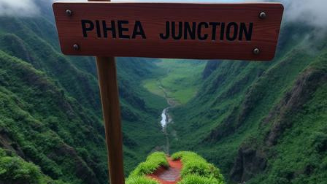
What is Pihea Vista Junction?
At its core, Pihea Vista Junction is a trail intersection located along the Pihea Trail in Kōkeʻe State Park. To reach it, you must drive to the very end of Highway 550 until you stop at the Puʻu o Kila Lookout, an incredible perch sitting at roughly 4,176 feet above sea level.
From the lookout, the Pihea Trail winds along the rim of the Kalalau Valley. After roughly 0.93 miles (about 1.5 kilometers) of hiking, you hit the junction. Here, you face a choice:
-
Go Right/Straight: Continue along the narrow ridge-line towards the Pihea Vista Overlook for dramatic coastal shots.
-
Turn South: Descend towards the boardwalks leading deep into the Alakaʻi Wilderness Preserve and the famous swamp trail.
The Two Paths: Alakaʻi Swamp vs. Kalalau Valley Views
The magic of this hike is the dramatic shift in scenery. Here is what you can expect depending on which direction you choose.
1. The “Rim Walk” (The Kalalau Valley)
If you continue straight past the junction or take the short spur to the Pihea Overlook, you are walking the “rim.” This section offers jaw-dropping, top-down views of the Na Pali Coast.
-
The View: You are staring 4,000 feet down into the Kalalau Valley. On a clear morning, you can see the ocean, the sharp green spires of the cliffs, and the entire northwest side of the island.
-
The Terrain: This is where the wind and rain have twisted the trees into strange shapes. The path is red clay and can be extremely slippery.
2. The Alakaʻi Swamp (The “Cloud Forest”)
Should you turn towards the swamp, you are headed to the Alakaʻi Swamp, which is actually a high-altitude plateau and the highest swamp of its kind on earth. This is not a muddy hole but a fascinating wilderness of bogs and stunted rainforest.
-
The Boardwalk: After about 2 miles from the lookout, you will transition from the muddy Pihea Trail onto wooden boardwalks. These elevated paths were built to protect the fragile bog ecosystem.
-
Kilohana Lookout: Follow the boardwalk for another 2 miles to reach the end of the trail at Kilohana Lookout, where, on a clear day, you can see all the way to Hanalei Bay.
Preparation Checklist (Read This Before You Go)
To ensure your safety and comfort, please review the following list. This area gets an average of 260 rainy days per year, and Mount Waialeale (nearby) is one of the wettest spots on the planet.
-
Footwear: Trail runners or hiking boots with aggressive tread. Do not wear flip-flops or flat sneakers. The red mud is like ice.
-
Attire: Quick-dry pants and a rain jacket. Cotton clothing will become heavy and freezing once saturated with rain or sweat.
-
Gear: Hiking poles, bug repellent (the mosquitoes are relentless), and a rain cover for your backpack.
-
Navigation: Download offline maps. The area is prone to dense fog that can obscure the trail.
-
Hiking Sandals (Optional): Some experienced hikers prefer Keen-style hiking sandals. They allow mud to wash through rather than caking up your boots in the deep clay sections.
Safety First: The Mud, The Fog, and The Time
Do not underestimate the Pihea Trail. While the stats (elevation gain of roughly 450-500 feet) suggest it is beginner-intermediate, the conditions make it feel advanced.
-
Deep Mud: The clay is notoriously slick. There are sections where you will have to pull yourself up using tree roots to avoid sliding down the ravine.
-
The Fog Factor: Visibility can change instantly. You might have perfect blue skies when you park, but by 9:30 AM, the valley can be completely socked in with clouds, leaving you with zero view.
-
Don’t Go Beyond the Vista: State park officials mark a clear warning: Caution – Do not go beyond the Pihea Overlook. The terrain beyond that point drops off steeply and is extremely dangerous.
Best Time to Visit Pihea Vista Junction
Because this is one of the rainiest regions on earth, timing is everything.
-
Season: The best months are the “dry” summer months from May to September.
-
Time of Day: Go early. Arrive at the Puʻu o Kila parking lot by 7:30 or 8:00 AM. The clouds usually begin to roll in by mid-morning, obscuring the views.
The Verdict: Is This Hike For You?
Yes.
Even if you don’t make it all the way to Kilohana, the first mile to the Pihea Vista Junction is a relatively wide, manageable path that offers “high payoff with exquisite Napali views”.
If you want to see the Alakaʻi Swamp, know that you are signing up for a long day (roughly 8 miles round trip) and you will get completely covered in mud. But the reward is seeing a wilderness untouched by time, where you can hear native birds like the ʻIʻiwi singing from the Ohiʻa trees.
Call-to-Action
Ready to tackle the Garden Isle? Share your hiking plans in the comments below. Are you team “Kalalau Valley Views” or team “Alakaʻi Swamp Adventure”? If you have already hiked this trail, drop your best mud-safety tips for first-timers below!
Don’t forget to visit the official Hawaii State Parks website or the DLNR Kauai page for the latest trail closures before you head out.